


Hiking
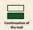
Signposting of trails
These are some of the signs you will find when you take the routes we describe below.
(SL) LOCAL PATH:


Route SL-CC 29 Santa Maria Hermitage
The language of stones. The valley’s history has been written and shown on the stones of its façades since the Middle Ages. On this route, we will find historical urbanistic symbols and elements that will remind us of its primitive inhabitants. Those interested in learning about the language of the stones are recommendeda peaceful route through the streets of the town.
From the high part of Tornavacas, next to Fuente de Santa Ana, we leave along a road that quickly ascends above the town, until it becomes a passage between stone walls, alternating a concrete with a dirt surface. We cross an oak wood and, after a fork, start descending amid cherry trees towards San Martín ravine along a narrow bridle path and crossing the ravine twice. After a short ascent, we come to a new crossroads on the right and 164 ft further we can see the ruins of the Santa María Hermitage. From the aforementioned point, we must descend along the track that brings us near the town, leaving the bridge over the river Jerte to the right, and now continuing uphill and straight ahead until we reach the starting point.


Profiles

Technical sheet
Route: Circular
Start: Tornavacas
Finish: Tornavacas
Length: 2.6 miles
Estimated time: 1h 15min
Difficulty: Low
Height difference : 545 ft
Height difference : 545 ft
HIM
